Six Utah OHV areas worth the drive
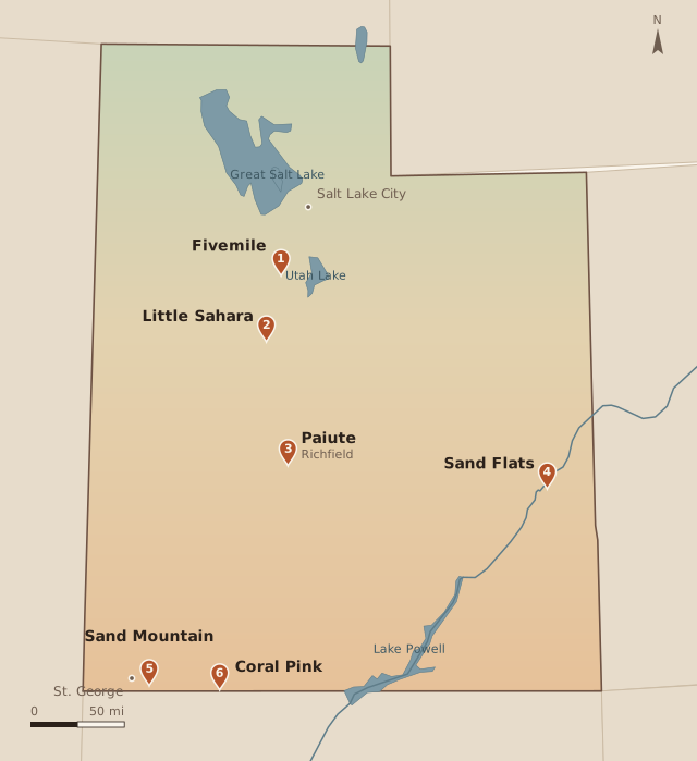
Six places cover most of the “where should we ride?” conversations in Utah. One is a dirt-road play area just west of the Wasatch Front. Two are open sand close to a city, one is designated slickrock east of Moab, one is a pink dune field with a campground, and one is a signed trail you can stay on for days. The state page behind all six is the Division of Outdoor Recreation’s OHV program. That office, inside the Department of Natural Resources, is where registration, the education course, and the dune-flag rule live. The dollar amounts below are extra, and only where the land manager posts a fee of its own.
The bike in the rest of this site is an electric dirt bike. Past the e-bike lines, Utah treats it as an off-highway motorcycle, which is an OHV. It needs a current registration and the education course before it rides public land. All six areas let that machine onto some of the ground. Open riding, where you may leave a track, is only where the manager has said so: the dunes at Little Sahara, the open area at Sand Mountain, and the open dunes at Coral Pink. Fivemile, the Paiute, and Sand Flats publish roads and trails.
Drive times are ordinary car times to one entrance. Downtown Salt Lake means State Street at 400 South. Downtown St. George means St. George Boulevard. A trailer, a Friday afternoon, or a different trailhead moves the clock. Read the linked page before you load the bike. These places close for fire, weather, and repairs.
Fivemile Pass Recreation Area
The Bureau of Land Management calls Fivemile Pass a popular OHV play area within an hour of Salt Lake City. Riders call it Five Mile. The visit page describes a large day-use parking area and many dirt roads, and it does not print a mileage for them. A 2021 decision designated 17,927 acres of this public land as a special area. That figure is the boundary, not a trail mileage. The visit page does not post a day-use fee, and it says dispersed camping is permitted without a fee. Five pit toilets are on the site. The published direction is Interstate 15 to the Lehi exit, then 25 miles west on SR-73 to the main parking area. From downtown Salt Lake that drive is about an hour. From downtown St. George, about 4 hours 30 minutes.
The visit page’s picture is a play area, not a signed trail and not a dune. It says to bring an OHV, an ATV, or a motorcycle. Dirt roads, a large parking lot, and room to camp. Holiday weekends are the busy version: that is when the BLM says people come to camp. A weekday is the same roads with less company.
The page does not print a route map, and it does not call the ground an open area. A 1997 BLM notice says a 1992 plan amendment designated 10,880 acres here as open to cross-country OHV use. That acreage is not the 17,927-acre special area, and the visit page does not repeat the open designation. Ride the dirt roads the page describes.
From Salt Lake this is the short one in the set, about an hour, short enough to ride and still be home for dinner. From St. George it is about 4 hours 30 minutes, in the same range as the drive to Little Sahara. The page lists five pit toilets and does not mention drinking water, so take what you will drink. The pin is the main parking area on SR-73. It is not a map of the tracks.
Little Sahara Recreation Area
The Bureau of Land Management calls Little Sahara Utah’s premier OHV destination: 63,000 acres of dunes, sagebrush flats, and juniper hills, with Sand Mountain rising nearly 700 feet. The visit page gives the size in acres. It describes a network of trails around Black Mountain and does not print a mileage for them. The use fee is $18 per vehicle per night, and that payment includes the campgrounds. An annual pass is $120 a vehicle, or $60 for seniors and people with disabilities. The BLM puts the entrance about 115 miles from Salt Lake City via Nephi. From downtown, figure about 2 hours 15 minutes. From downtown St. George, figure about 4 hours. State rules for the machine, including the dune flag, sit on the DNR site.
The open sand is a different day from a trail system, and it is not the whole recreation area. The OHV area page puts the dune riding at 23,000 acres, inside the larger area. The lower dunes southwest of Black Mountain are the learner terrain, wide and less steep. White Sands, at the north end, is the middle ground: easy access to the sand and a set of bowls. Sand Mountain is the hill people come to climb, and it is a poor place to find out the bike is too much. Around Black Mountain the ground turns to a trail network if you would rather ride dirt than paddle through sand. The Rockwell area on the northwest side is the place you shut the bike off. It is a vehicle-free 9,000 acres. Children’s play areas are closed to motors too, even where the sand has moved the fences. Off the dunes, the safety page says stay on the designated roads and trails and off the vegetation.
A quiet e-moto does not get a pass on the flag. Other riders come over a blind dune face. The safety page requires a red or orange whip at least 8 feet above the ground. The state FAQ also allows that flag on a helmet, at least 18 inches above the rider’s head. The campground roads are paved, the riding is not, and cell service inside the area is poor. The visitor center is closed from November 8, 2026, through spring 2027. The recreation area itself stays open, and the fee can be paid at a kiosk. Sand and loose climbs are where a claimed range falls off, so plan the day from the camp charger. The registration file is the other paper to have in the bag.
Paiute ATV Trail
The BLM’s Paiute page gives the mileage the other areas don’t: the main trail is 275 miles, with over 1,000 miles of marked side trails, plus still more spurs. The same page lists no day-use fee for the trail. You still need a current Utah OHV registration, or the nonresident permit, through the DNR OHV program. Richfield is the practical big-town start. About 2 hours 30 minutes from downtown Salt Lake, and about 2 hours 30 minutes from downtown St. George. The trail also meets the pavement in Fillmore, Beaver, Marysvale, Circleville, and a string of smaller towns, so the drive moves with the trailhead you pick.
The Paiute is a ride you start from a sidewalk. The signed main route leaves town, climbs into the Fishlake high country, drops into the next valley, and comes out in another town where you can eat and fuel. It crosses several mountain ranges. Loops and side trails fill the country between them, which is why one weekend becomes a long one. Width limits are part of the system. On the Fishlake, trail riding is held to 50-inch and 60-inch trails, and anything wider stays on routes marked open to all vehicles. Cross-country travel is prohibited. A dirt bike fits the 50-inch trails. A machine wider than 60 inches does not. The Fremont Indian State Park trailhead says the main Paiute and side trail 79 are 50 inches or less, while side trails 13 and 76 there are open to any vehicle.
What the day feels like depends on the elevation you pick. The Skyline trailhead sits at 10,235 feet in spruce and aspen, and the forest lists that site as a June-through-October season. Lower down, the riding between the towns is juniper, sage, and two-track. Either way you stay on the marked route. A 275-mile main trail is a multi-day ride if you actually follow it, and the side trails are where a second and third day come from. Charge overnight in town. The high loops spend a battery on the climbs.
Sand Flats Recreation Area
Sand Flats, just east of Moab, is the slickrock. The BLM and Grand County run it together: 9,000 acres of domes, bowls, and fins, with the La Sals on the skyline. The visit page counts almost 30 miles of jeep trails, and that is the motorized mileage it publishes. A motorcycle pays $5 for a seven-day pass. A private vehicle pays $10 for seven days. An annual day-use pass is $35. Camping in the individual sites is first come, first served, at $20 a night per vehicle. A Utah State Parks pass does not cover this gate. From downtown Salt Lake, about 4 hours. From downtown St. George, about 5 hours 15 minutes, up I-15 and across I-70. The Grand County page is the local companion to the BLM one, and the DNR OHV program is still the registration page.
The ground is stone, and there is no open play area, campgrounds included. Grand County says every vehicle stays on the designated road or trail, the 4x4 trails are limited to 15 mph, and leaving the route is a class A misdemeanor. Slickrock is the loop drawn for motorcycles. It stays open to motorcycles and mountain bikes, and it is closed to every four-wheeled vehicle. The first 8.6 miles of Porcupine Rim share the road with bikes and other motorized vehicles. Mile 8.6 is the turnaround for anything with a motor. The singletrack after that, and LPS, are closed to motors. A registered e-moto is in the motorcycle group. A Class 1 e-bike allowance is a different permission, and it does not open that singletrack.
The ledges and fins reward a rider who is happy at walking speed for long stretches, and they punish a hot battery and a light tire. Almost 30 miles of jeep trail is a full day on the rock, because the hard lines are slow. The honest plan is one loop, a margin of charge, and no promise of a second loop after lunch in July.
The gate is the whole fee area. Pay at the entrance station on Sand Flats Road, a few minutes east of downtown Moab, and the pass covers that recreation area. Summer on the slickrock is exposed. There is little shade, the stone throws the heat back, and a midday start is the hard way to learn the range. Spring and fall are the weeks the place is built for. The campgrounds inside the gate are the easy overnight if a site is open. Individual sites are first come. The group sites are the ones you can reserve.
Sand Mountain
Sand Mountain is the open riding area on the east side of St. George, against Sand Hollow State Park. The BLM designated it an open OHV area, which means the riding is not limited to a drawn trail. The visit page describes miles of technical trails and open sand, and it does not print a total for either. It also lists no fee. Waddy’s Corral, half a mile south of Sand Hollow Road off State Route 7, is the developed BLM trailhead. From downtown St. George that side of the area is about 35 minutes. From downtown Salt Lake, about 4 hours 45 minutes.
The feel is red sand and rock with the reservoir on one side and the Hurricane Cliffs, the Pine Valley Mountains, and the Arizona Strip in the view. The high point is about 4,000 feet, so this is low desert: a morning ride in summer, and a full day once the weather cools. Because it is an open area, you can leave a tracked path and cross the sand. That freedom is rare in Utah, and it is the reason the boundaries matter. Stay inside the area the BLM signs. The state’s OHV laws page requires a red or orange whip in designated dune areas. The rule that names them, R650-410-1, includes Big Sand Mountain in Washington County. That is this dune area beside Sand Hollow, not the hill of the same name at Little Sahara. The BLM visit page does not print the flag. The state rule does.
The park next door is the DNR piece of this trip, and it charges separately. Sand Hollow’s fee page lists a day-use fee of $25 a vehicle for Utah residents, $10 for Utah residents 65 and older, and $35 for nonresidents. Walk-in is $5. That fee is the park gate. It is not a fee the BLM lists for starting at Waddy’s Corral. The reason to pay it is the Sand Pit campground, which was built for trailers and has a ride-out toward the dunes, plus water, showers, and a lake at the end of the day. Dispersed camping on the BLM land follows the usual 14-days- in-28 limit, with no hookups. For an e-moto, a partial-hookup site in the park is the one with a plug.
Coral Pink Sand Dunes State Park
Coral Pink is the DNR area in this set. Utah State Parks runs it, and the park’s 2026 brochure says riders have 1,200 acres of dunes, about 90 percent of the dune field. A 265-acre conservation area is closed to protect the Coral Pink tiger beetle. The park does not publish a trail mileage, because the ride is the sand itself. Day use is $15 a vehicle, up to eight people. Utah residents 65 and older pay $10. Camping is $28 a night in the older sites, with no hookups, or $45 in the newer sites with water and electric. The park is open during daylight hours. From downtown St. George the southern route through Hurricane is about an hour and a half. From downtown Salt Lake, about 5 hours.
The dunes are pink, and the juniper and pinyon sit in them in islands, so the view is sand and then a dark tree and then sand again. Wind moves the hills. The park says the dunes can shift as much as 50 feet a year. It is a smaller day than Little Sahara, and you can see the edge of the ride. The conservation closure is real, and the rest of the dune field is open to OHVs. People hike and sandboard the same hills, so the riding is shared with people on foot.
The park’s OHV safety page is the short list for the dunes: an orange or red whip on every machine, a helmet for anyone under 18, and a current registration. That page tells parents that youth riders need the certification course. The Division of Outdoor Recreation’s current FAQ is the broader rule. Every OHV operator takes the appropriate course before riding public land, the free adult course or the youth course.
From St. George this is the easy dune day, short enough to ride in the morning and be back for a late lunch. From Salt Lake it is a long drive for 1,200 acres, long enough that a night in Kanab makes more sense than a there-and-back. The campground is a few dozen sites. Reserve one if the trip depends on a pad.
Before you go
The area fee and the state registration are two different payments. A Utah plate or the nonresident permit is the one every public-land ride needs, and the steps we walked through are on the registration page. Operators also take the OHV education course once, adults and youth on separate courses, before riding public land. On a motorcycle, a helmet is required for riders under 18 on any public land.
The whip is not a rule for every sandy mile in this post. Utah Admin. Code R650-410-1 requires it at three designated dune areas: Little Sahara, Big Sand Mountain beside Sand Hollow, and Coral Pink. Fivemile Pass, the Paiute, and Sand Flats are not on that list. The OHV laws page calls for a red or orange whip in those dune areas. The FAQ gives the size: at least 6 by 12 inches, mounted at least 8 feet up, or on the helmet at least 18 inches above the rider’s head. The OHV program is the DNR page to check when a fee or a rule looks out of date, which it will. The figures in this post were read from the agency pages on November 8, 2026.